42.4 km | 886 m ascent | 891 m descent | Moving time 2:38:37 | Ascent time 1:26:26 | Descent time 1:08:30 | Maximum gradient +23.8% / −19.2% | Maximum speed 51.6 km/h | Average speed 16.1 km/h | Eight recorded climbs
It was advertised as a social ride: easy pace, plenty of stops to close the group, coffee in Armeni and absolutely no unnecessary suffering. All perfectly reasonable, provided nobody examined the figures too closely.
The final reckoning was 42.4 kilometres, 886 metres of ascent and 891 metres of descent. Of the time spent moving, one hour, twenty-six minutes and twenty-six seconds was spent climbing and one hour, eight minutes and thirty seconds descending. Eight climbs were recorded, the steepest gradient reached 23.8 per cent, and somewhere in the opposite direction we managed −19.2 per cent and a maximum speed of 51.6 km/h.
These are not, perhaps, the first figures that spring to mind when contemplating a gentle Sunday morning among friends, but statistics can be terribly misleading things. Better to concentrate on the coffee.
We left Kokkino Chorio at eight and took the familiar tarmac through Kambia, with the White Mountains away to the south and the Drapanos country behind us. There is something particularly agreeable about beginning a ride by descending Four Hills. The bicycle gathers speed, the morning air is still cool and gravity, so often our adversary in Crete, appears for once to have joined the group.
This generosity, as experience should have taught us, is temporary.
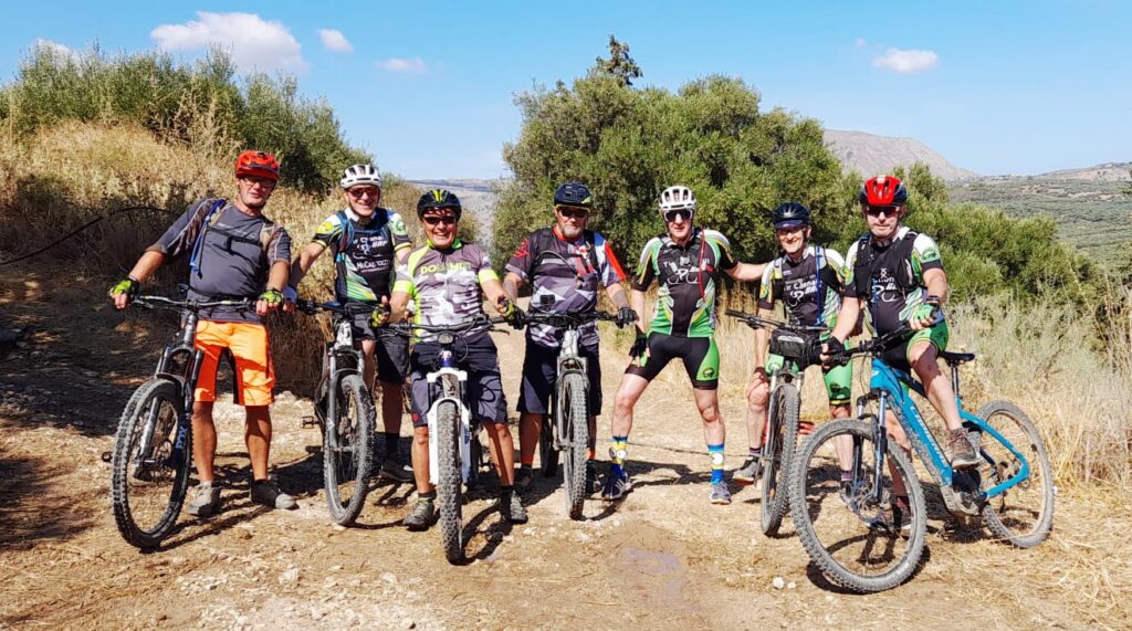
At Gavalohori the little party became a proper group. Anthony, Nick and Gerold joined us from the White Mountains E-MTB Club, together with Gerald, Frank, Francois, Robert and Declan from Tír Chonaill GAP Cycling Club, who were joining us for the morning.
Tír Chonaill is Irish for “Land of Conall”, the traditional Gaelic name associated with County Donegal. Our own club takes its name from the White Mountains — the Lefka Ori — the great limestone range that dominates western Crete, its high country appearing white from winter snow and, through the warmer months, from the pale exposed rock.
So there was something rather fitting about the meeting at Gavalohori: riders carrying the name of an old Gaelic land joining riders carrying the name of the mountains above us. Tír Chonaill and the White Mountains — two very different landscapes brought together for a morning on E-MTBs.
Tír Chonaill GAP Cycling Club have an excellent motto: #NoRiderLeftBehind. Four words that neatly capture the camaraderie and responsibility that make a good cycling club.
The White Mountains E-MTB Club operates according to a rather different philosophy. Our motto is the Three Cs: Coffee, Cake and Climbs. The order is important. Coffee provides the motivation, cake provides the energy, and climbs provide the reason why both were necessary in the first place. On this particular morning we managed all three, although, as the ride data would later demonstrate, we had been unnecessarily generous with the third.
With introductions made and the enlarged group together, we turned back through Aspro, where the road and tracks begin their usual conversation with the old agricultural landscape. Olive trees crowd the slopes and terraces, stone appears everywhere — in walls, field boundaries, abandoned structures and heaps cleared from land that has been worked for generations — and the modern rider passes through it all rather faster than those who made the tracks could ever have imagined.
Then came the Roller Coaster, a name of our own rather than anything recognised by cartographers, but one which describes the track well enough. Quick rises and sudden drops encourage the bike to run, while a commercial roller coaster would admittedly offer barriers, regular safety inspections and somebody whose continued employment depended upon your arriving safely at the other end. We have none of these things, although we do have suspension and a touching faith in hydraulic brakes.
Beyond it, the route passes into the Olive Groves, where the land becomes quieter and more enclosed. These are not ornamental trees arranged for visitors, but part of a working landscape of tracks, terraces, irrigation pipes, walls and small structures, each put there because somebody needed it. At this time of year the track, like many of the older routes, is becoming overgrown, with bamboo and thorn bushes leaning in from either side to administer the occasional whipping to passing riders. It is best regarded as a free local service. The modern road may pass around this older geography, but on a mountain bike we repeatedly drop back into it.
The Prophet Elijah Climb provides one such return, although contemplation of the landscape becomes increasingly difficult as the gradient rises. Chapels of the Prophet Elijah — Profitis Ilias — have a particular association with high places throughout Greece, and Crete is no exception. The cyclist is entitled to the simpler observation that whoever selected these elevated sites was not carrying a spare E-MTB battery.
By the top, conversation had diminished considerably. This is one of the dependable social effects of climbing: a group that ten minutes earlier was discussing tyres, batteries, and the questionable competence of absent friends suddenly becomes deeply interested in breathing.
We closed the group and continued towards Tsivaras and the Water Tower. Such structures are among the least romantic but most useful landmarks in the Cretan countryside, part of the infrastructure that keeps villages and agriculture functioning. Their position is dictated by the elementary requirement that water stored high can be distributed to places lower down.
Unfortunately, the same principle means that cyclists wishing to visit water towers generally have to go uphill.
From there came the Rough Track and Short Drop, and then one of the less celebrated monuments of Apokoronas: the Wet Tunnel.
It is a concrete underpass. No battle was fought for it, no resistance courier is known to have hidden there, no archaeologist has expressed the slightest interest in excavating it, and Patrick Leigh Fermor, so far as I know, never slept in it. Yet repeated passage has given it a place in our own geography as definite as any hill or village.
It is a tunnel, and it is wet. The naming committee felt further research unnecessary.
As we rode through, several of the riders discovered another of its properties and began sending loud “whoop, whoop” calls into the darkness, apparently to test the acoustics. The tunnel returned them with suitable enthusiasm and, judging by the laughter emerging from the far end, passed the test.
The water and mud on its floor also provide a useful lesson in group riding. Enter immediately behind another rider and his rear tyre will transfer a representative sample of the tunnel onto your face, glasses and clothing. Local geology can therefore be studied without the inconvenience of dismounting.
After the tunnel, Armeni finally appeared and with it Kiosky, coffee and chairs. The village sits in the green country of the Koiliaris basin, a very different landscape from the drier ground around Kokkino Chorio and Drapanos. Water explains much of that difference. Springs, streams, irrigation and the river have shaped both cultivation and settlement here, while the great plane trees around Armeni are a visible expression of that abundance.
Linda and Andrew, members of the WMCC Road Cycling Section, joined us for coffee. They had sensibly arrived by car, thereby enjoying the coffee and company while avoiding all the unnecessary business of actually cycling there.
We considered very little of the surrounding geography while drinking coffee. Helmets came off, cakes appeared and for a brief period the ride actually became the social occasion advertised at the beginning. Batteries were compared, mechanical ailments were diagnosed by people with no recognised engineering qualifications, and previous rides grew steeper and more hazardous with every telling.
The difficulty with a comfortable chair halfway through a ride is that eventually one has to leave it, and so we descended from Armeni towards the Koiliaris.
The river is one of the defining physical features of this part of Apokoronas. Its water, tributaries and springs have shaped the vegetation and agriculture of the basin, while roads, tracks, irrigation works and cultivated ground have accumulated around it. Down here the country feels enclosed and green, quite unlike the drier limestone ridges from which we had started the morning.
The Koiliaris Loop took us through this lower ground before we picked up the Track Above the River. Riding above the water gives a different perspective on the basin: the river below, cultivation gathered around it and the higher ground enclosing it on either side. It is precisely the sort of old line that makes more sense from a bicycle than from a car, where the modern road tends to hurry you past the relationship between water, field and settlement.
There is, however, an unavoidable geographical principle involved in riding beside rivers in Crete. If you descend into their country, sooner or later you have to climb back out.
The Crap Climb deals with this requirement.
Some names along our routes have emerged from history. Others come from churches, villages, landscape features or objects encountered along the way. Occasionally I spend considerable time with wartime maps, historical accounts and old place names trying to understand how a particular piece of ground acquired its significance. No such scholarship was required here: someone rode the climb, someone expressed an opinion, and the opinion became the name.
On this occasion the hill also demonstrated that merely possessing an electric motor does not exempt a rider from the laws of physics. Not everyone got up straight off. Loose ground, gradient, line choice and momentum still matter, and once forward movement disappears on a steep rough climb, the motor can do little except accompany you while you put a foot down.
There were second attempts, while those already at the top were afforded an unexpected opportunity to appreciate the landscape. Eventually riders and bicycles were reunited and the promised easy social pace continued, now assisted by the fact that nobody was in immediate danger of riding particularly quickly.
Then we returned to the Wet Tunnel.
Crete contains many places one might willingly visit twice in a morning: an ancient church, a mountain viewpoint, a shaded spring, perhaps even Kiosky if circumstances permitted. The Wet Tunnel would not normally appear high on the list, but through we went again, collecting a second geological sample for comparison with the first.
Beyond it came the Short Climb. Here it is important to understand that the adjective refers exclusively to distance; no promise concerning gradient, comfort or emotional wellbeing should be inferred from it.
Over the Hill brought us briefly onto tarmac, smooth and predictable beneath the tyres. After loose stone, ruts and broken tracks there is something almost suspicious about a surface that simply allows a bicycle to roll, but the outbreak of civilisation did not last.
Ahead was Tony’s Gully.
Names like this have become our own informal map of Apokoronas. They rarely appear on conventional maps, but within the group a mention of Tony’s Gully is enough to identify a particular piece of ground, just as Roller Coaster, Wet Tunnel and Crap Climb require no coordinates. Repeated riding has produced a second geography laid over the official one, built from experience rather than cartography.
Tony’s Gully duly deposited us towards the next item on the programme: Brian’s Climb, otherwise known as Head Butt Hill. Any climb possessing two names deserves a degree of caution, and Brian’s Climb is certainly the respectable version. Head Butt Hill is the version produced by experience, and one suspects it carries rather more useful information for the approaching rider.
By now the social nature of the morning was beyond dispute. We were certainly spending a great deal of time together, principally because we kept stopping at the tops of hills waiting for one another.
From there we made our way towards Douliana, one of those villages that seems particularly well fitted to its ground. Stone houses, narrow lanes and older buildings sit among olive and cypress, while the surrounding tracks still connect village, field, church and neighbouring settlement in ways that pre-date the modern road network.
It is this relationship between the villages and their old approaches that an E-MTB reveals particularly well. We do not simply arrive at Douliana by road, pass through and leave. We approach through the country that belongs to it, along tracks whose purpose was agricultural and local long before anyone thought of riding them for amusement on a Sunday morning.
There was, however, another climb to attend to: Plague Hill. The name is not one that encourages optimism, and after Crap Climb, Tony’s Gully and Head Butt Hill one might reasonably conclude that whoever names our tracks has a rather bleak view of recreational cycling.
The compensation was Plague Hill Descent. A climb makes demands; a descent returns something. The bike begins to move beneath you rather than against you, the motor becomes largely irrelevant, and line choice replaces sustained effort. Stone, ruts and loose surfaces still demand attention, but this is the sort of riding for which the climbing has purchased admission.
The descent brought us back towards Gavalohori, which produced the curious sensation of returning to somewhere we had already visited several hours earlier. A less imaginative route planner might have concluded that arriving back at Gavalohori constituted a perfectly respectable end to the expedition.
For our friends from Tír Chonaill, it was. This was their last day of riding in Crete, and at Gavalohori we said our goodbyes. After a morning of tracks, climbs, descents, coffee, a distinctly wet tunnel and rather more ascent than the words “social ride” might have suggested, Tír Chonaill and the White Mountains parted company — hopefully to ride together again somewhere in the future.
Those of us returning to Kokkino Chorio, however, still had some unfinished business. There remained the small matter of Aspro Track — and, beyond it, Four Hills.
By this stage more than forty kilometres were accumulating in the legs and the morning’s collection of climbs had removed much of the novelty from the concept of gaining height. The countryside, however, remained the same mixture of olive ground, stone, tracks and scattered buildings through which we had started hours earlier, and gradually the familiar ground around Aspro brought us back towards the final reckoning.
Four Hills.
We had descended it at the beginning of the morning when everyone was fresh, cheerful and enjoying gravity’s unexpected generosity. Now the account had arrived for settlement.
Four Hills Climb is the return price, and the ride data makes the final insult rather precise. The last recorded climb ran for 1.6 kilometres, averaged 7.2 per cent and reached 18.7 per cent at its steepest, gaining roughly 100 metres before finally releasing us onto the higher ground.
There is a particular cruelty in finishing a loop by climbing the same country that provided such effortless pleasure at the start. Every metre casually surrendered in the cool of the morning has to be purchased again at the end, only now with forty kilometres already in the legs and considerably less enthusiasm for the transaction.
From the top came Kambia and finally Kokkino Chorio, closing the loop where it had begun.
The computer now supplied the figures we had wisely ignored at the start: 42.4 kilometres, 886 metres climbed, 891 metres descended and eight recorded climbs. We had spent 1:26:26 going uphill and 1:08:30 coming down, reached a maximum climbing gradient of 23.8 per cent, a descending gradient of −19.2 per cent, and at some point gravity had repaid us with 51.6 km/h.
But those numbers describe only the physical route. The morning had taken us through another, less measurable Apokoronas: olive groves and village lanes; the high ground of Prophet Elijah; a utilitarian water tower; the wet concrete darkness beneath a road; the greener country of Armeni; the Koiliaris and its cultivated basin; Douliana among its stone, olive and cypress; and the old tracks still stitching these places together.
Over that older landscape we have laid another geography of our own. Roller Coaster, Wet Tunnel, Crap Climb, Tony’s Gully, Head Butt Hill and Plague Hill will not trouble the cartographers, but mention any one of them among the people who ride here and no further explanation is necessary.
The first landscape has accumulated through generations of people living and working in Apokoronas. The second has largely been created by people on mountain bikes deciding that the names on the map were insufficient.
And somewhere among all of this remained the original promise: easy pace, plenty of stops to close the group, coffee in Armeni and absolutely no unnecessary suffering.In fairness, we kept the easy pace, stopped regularly, had coffee and got everybody round. We even provided numerous opportunities to stop, look back across the countryside and pretend that this had been the intention all along.
As for the suffering, I maintain that all 886 metres of it were strictly necessary.
The remaining 0.4 kilometres were probably social.
As for the suffering, I maintain that all 886 metres of it were strictly necessary.
The remaining 0.4 kilometres were probably social.
Alan McWilliams
In the Shadow of the White Mountains
September 2026