Some ruins are reached by following a sign. Others are found by following the shape of the ground. The Koules above Neo Chorio belongs to the second kind. From below, it is little more than a broken line of ochre stone among the pale limestone, thorn and burnt grass of early September. Only when you stand within its walls and look out across Apokoronas does the building begin to explain itself. The important thing about the Koules is not simply the building. It is where the building was placed.
The morning was already clear as I left Kokkino Chorio, the long summer had dried the earth, and there was no softness left in the tracks or the vegetation. The completed loop would cover 37.2 kilometres and accumulate 830 metres of ascent, reaching a high point of 350 metres. Its steepest recorded climb was 19.6 per cent and its steepest descent 16.8 per cent. The Koules itself stands at only about 160 metres, so the figures belong to the whole movement across the country rather than to the final climb alone. The ride rose and fell through Apokoronas before reaching the low, strategic height south-east of Neo Chorio.
The ground immediately around the fort was hard and untended. Broken stone lay among the dry stems; thorn bushes had occupied the interior; collapsed masonry concealed the old floor levels. There was no clear visitor’s route through it. The surviving walls had to be approached carefully, first from one side and then another, because the original plan no longer reveals itself at a glance. A rounded tower appears first as a mass of rough stone. Then the long wall comes into view, pierced at regular intervals by narrow openings. Beyond it are the cultivated plain, the villages at the foot of the White Mountains and the mountain wall itself.
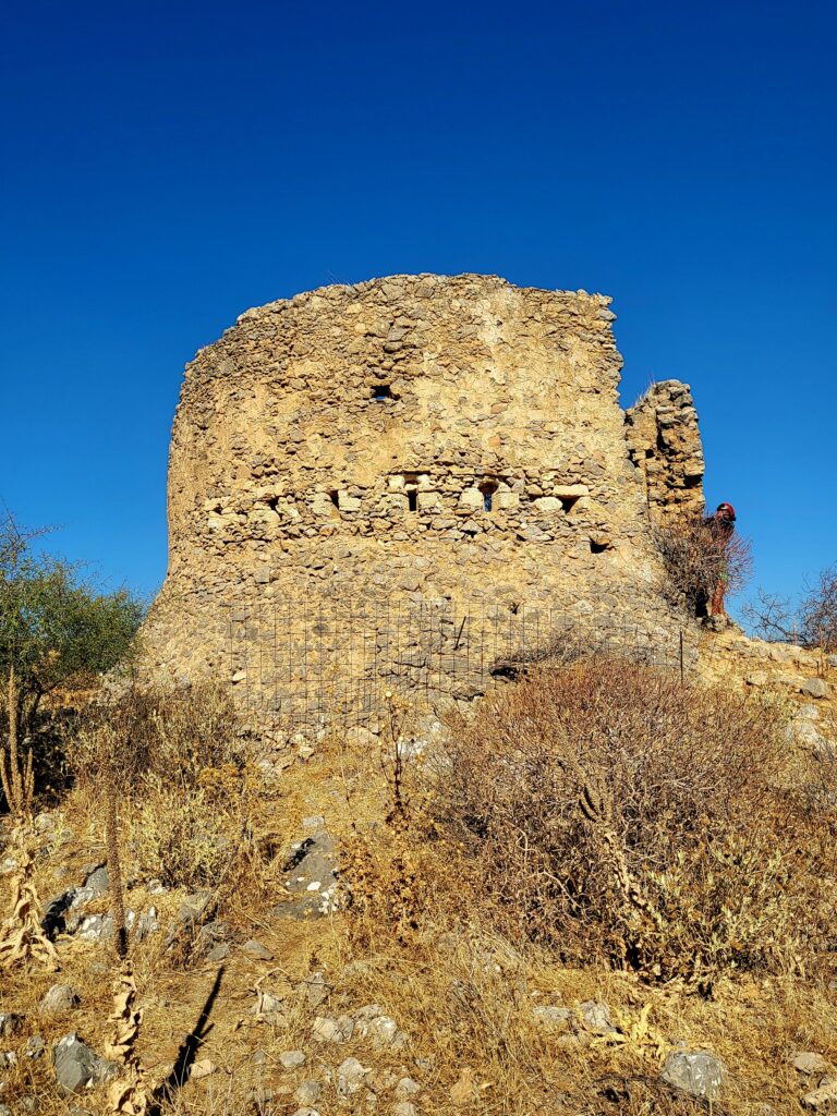
The position was not chosen for grandeur. It was chosen because men, animals, supplies and information had to pass through the ground below. The fort watched the Kambos–Stylos–Kalyves area, the settlements of the Riza along the northern foot of the Lefka Ori, and the routes by which Apokoronas communicated with Keramia through Ramni and Samonas. To the north lay the coast and the landing places; to the south, the mountain approaches; between them ran the village roads and tracks. A garrison on this hill did not need to see every traveller closely. It needed to see where movement began, where it was heading and which neighbouring position should be warned.
That was the purpose of the Koules across Crete. During the great Cretan Revolt of 1866–69, the problem confronting the Ottoman authorities was not simply how to defeat armed groups in battle. It was how to control the country between one action and the next. The principal towns and established forts could be held, and military columns could be sent into the interior, but the revolutionaries moved through the mountains, crossed from one province to another, drew support from the villages and received men, weapons and supplies through small coastal landing places. Once a column had passed, the ground behind it could become uncertain again.
The Ottoman answer was a permanent network of small forts, towers and blockhouses placed at the points through which movement was obliged to pass. In the contemporary documents they were described as towers or blockhouses. The name by which they are now known comes from the Turkish kule, meaning tower; in Crete, the singular became Koules and the plural Kouledes. They were not scattered at random. They were set on commanding hills, beside roads, above defiles, at the entrances to plateaux and near harbours. Most were close enough to another post for warnings to be passed by sound or by fire. A patrol could move out from one, be observed by the next and remain within a wider system of support.
The scheme became systematic after Hüseyin Avni Pasha arrived in Crete as commander-in-chief of the Ottoman forces in October 1867. In a memorandum of February 1868, he described four principal lines of fortified control. In the east, one ran across the narrow isthmus from Ierapetra to Pachia Ammos. A second was intended to link Candia, now Heraklion, with Tympaki. In the west, a line ran from Chania through Alikianos, Lakkoi and Kandanos to Kastelli Selinou, the modern Paleochora. The fourth was planned from Rethymno, through the Sellia pass in Agios Vasileios, to Frangokastello on the south coast.
These main lines were joined by secondary chains. Three Koules guarded the coast near Fodele. Others controlled the approaches through Amari and the valleys leading south from Rethymno. In the east, towers at Malles, Riza, Kentri, Episkopi, Vasiliki and Pachia Ammos helped close the Ierapetra isthmus. Along the southern and western country, positions at Frangokastello, Loutro, Agia Roumeli and above the Samaria Gorge watched the small harbours, mountain exits and paths by which the revolutionaries could move or be supplied.
Road building formed part of the same plan. New military roads were being opened from Chania towards Lakkoi, Malaxa, Keramia and Apokoronas, and through Apokoronas towards Kalyves, Almyros and eventually Rethymno. Other works were intended to connect Kandanos with Kastelli Selinou. The roads allowed troops to move quickly between the fortified points; the Koules protected the roads and made that movement possible. Together they reduced the open spaces in which revolutionary groups could assemble, cross the island or disappear from Ottoman observation.
Western Crete received the greatest concentration. By 9 September 1868, seventy Koules were reported as completed across the island, forty-eight of them in the Chania district. Twenty stood in Apokoronas and twenty-two in Kydonia. Published totals for the complete network vary, partly because towers were being constructed, abandoned, altered and sometimes demolished within a short period, but there is no doubt about the density of the western system. It followed the landscape from the coast towards the White Mountains and then into the approaches to Sfakia.
At its northern end stood the coastal fortifications of Souda and the great Koules at Aptera. From there the line continued through Apokoronas. There were two Koules at Neo Chorio, two at Kaina, one at Vamos, three in the Ramni area, and others at Kares, Melidoni, Vafes, Embrosneros and Alikambos. Farther south, the position at Krapi communicated with the two forts on the Askifou Plateau, linking the system of Apokoronas with the country of Sfakia. Looked at separately, each was a small stone building. Looked at together, they formed a military arrangement laid over the existing geography of villages, passes and roads.
The Neo Chorio Koules belonged to this arrangement. It was not the largest of the forts and it does not possess the severe completeness of the surviving structure at Aptera. Its value lay in the ground it overlooked and in its relationship with the neighbouring posts. The main building was rectangular, aligned approximately east–west, and measured about twenty metres by seven metres without its rounded defensive work. Its long walls were lined with closely spaced rifle loopholes. Local descriptions give it elevated semicircular positions at both ends; the more recent architectural study identifies clearly the western semicircular termination and suggests that the larger building developed from, or incorporated, a smaller earlier tower.
Some accounts state that the Ottoman fort was erected on the site of a Venetian tower. That is possible, but the evidence presently available does not establish a Venetian origin for the surviving structure. The safer conclusion is that the building visible today belongs to the Ottoman programme of the late 1860s, probably enlarging an earlier small watchtower whose precise date has not been securely demonstrated. It is usually dated to 1867, although the official dating of the complex is more broadly 1866–69.
A second and smaller Koules once stood on the opposite height. Between the two was a cistern which collected the water required by the garrisons. Local tradition describes the smaller fort as the fortified residence of the commander. The existence of the second position and the cistern is well attested; the identification of the building specifically as the commander’s residence is less certain. What matters militarily is the paired arrangement. The two positions watched the intervening ground and supported the same area of observation.
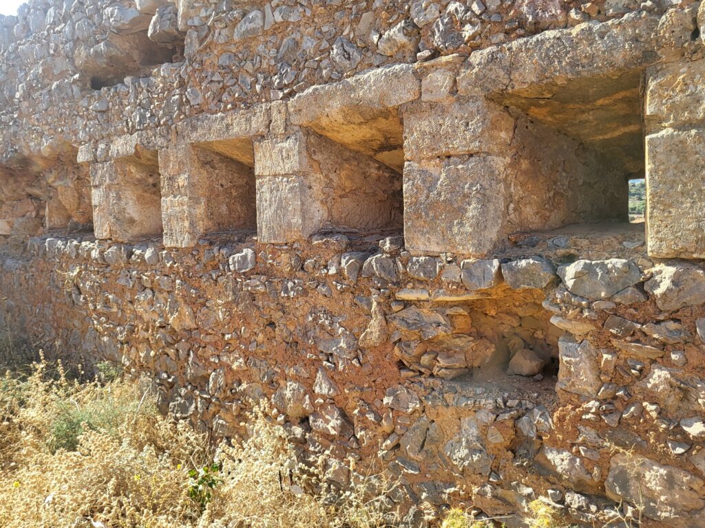
The rifle loopholes are now the clearest evidence of how the larger fort worked. From outside, each is a narrow slot, presenting as little opening as possible. Inside, the stonework widens sharply so that a soldier could observe and fire across a broader arc while remaining protected by the thickness of the wall. Studies of the Cretan Koules give these openings as approximately eight to ten centimetres wide and twenty-five to thirty centimetres high. At Neo Chorio they were set unusually close together, generally between eighty centimetres and one metre apart. Rough local stone formed the body of the wall, but larger and more carefully worked blocks were used for the jambs and lintels. Seen from inside, they are unmistakably firing positions rather than windows.

The roof and internal floors have disappeared. Without a complete measured plan and archaeological investigation, it would be unwise to assign particular purposes to each surviving compartment. Comparison with other Cretan Koules suggests the normal provision of space for the garrison and its commander, ammunition and stores, cooking and other necessary functions. Timber beams would once have carried the floors and roof. When those failed or were removed, the unprotected wall heads were left open to rain, heat, roots and the gradual loosening of their rubble cores.
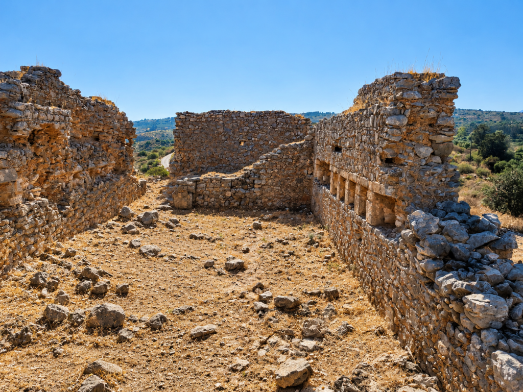
According to a December 2012 letter quoted by Χανιώτικα Νέα, the Greek Ministry’s Service of Modern Monuments and Technical Works of Crete dated the Neo Chorio fortified complex to the period of the 1866–69 revolt and identified it as part of the Ottoman network constructed to contain the Cretan revolutionaries. The same inspection warned that abandonment, exposure to the weather and possible damaging human activity were steadily leading towards the complete disintegration of the monument. It recommended urgent support for the unstable sections and measures to prevent further harm.
The warning is easy to understand when standing there. The tops of the walls are open, substantial areas have already fallen, vegetation has taken hold within the masonry, and loose stone fills parts of the interior. Yet enough remains to read the building. The long wall still holds its line. The firing apertures still direct the eye outward. The rounded work still covers the approach. Beyond them, almost everything the garrison was placed to observe remains in view.
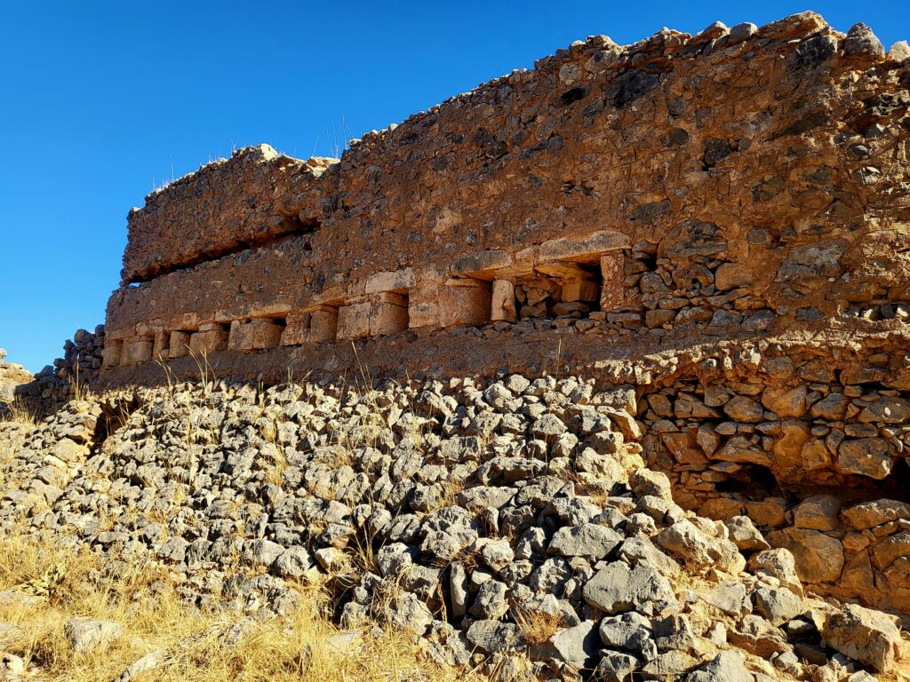
The halt at the fort accounted for part of the difference between the moving time of 2 hours 27 minutes and the elapsed time of approximately 3 hours 24 minutes. The average moving speed was 15.1 kilometres per hour and the maximum was about 40.6 kilometres per hour. Those figures describe the physical journey, but the reason for stopping lay in the stonework and the view. This was a place that required time on foot: looking along the inner face of the wall, examining the deep splays of the loopholes, and then turning to see exactly what lay within their arcs.
Afterwards, the loop continued back to Kokkino Chorio. From farther away, the Koules once again became difficult to separate from the hill. Its masonry shared the same colours as the exposed rock and the September grass, and the broken outline carried none of the authority the completed fort must once have possessed. Its military purpose, however, remained clear. The Ottoman administration had selected this height because the country below could be watched from it and because the post could form part of a succession of positions reaching across Apokoronas and towards the mountains.
The Koules are often treated as isolated ruins: a tower above a village, a few walls beside a track, a familiar place-name whose meaning has been partly forgotten. They make better sense when read together. They were the fixed points of a system designed to control a mobile population and an elusive revolutionary war. Their locations record the routes that mattered in the late nineteenth century: the road to a harbour, the entrance to a plateau, the saddle between valleys, the track by which one province communicated with another.
That is why the ruin above Neo Chorio matters. It does not need to be complete to explain the landscape. The ride to it crossed 37.2 kilometres of the same ground that the fort once helped to supervise, climbing through a country divided by ridges but joined by roads, tracks and lines of sight. From the saddle, the hill was a destination. From inside the Koules, the whole of the surrounding country became the subject.